Australia is enhancing smart bushfire monitoring by combining satellite technologies, artificial intelligence and real-time data processing, with SmartSat CRC leading this transformative effort to improve detection, prediction, and response capabilities nationwide.
These developments are reshaping how fires are detected, analysed and managed, supporting faster, more accurate and increasingly predictive systems. The approach enhances existing emergency response frameworks while strengthening long-term technological capability and resilience across Australia’s fire monitoring and disaster management landscape.
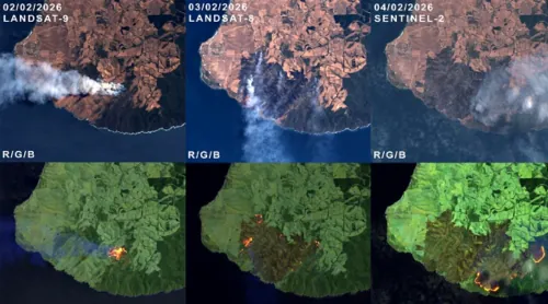
At the core of this transformation is a multi-layered satellite observation network. Geostationary satellites provide continuous, wide-area coverage with frequent updates, while polar-orbiting satellites deliver higher-resolution imagery at regular intervals.
Together, these systems support both persistent monitoring and detailed environmental analysis. Advances in thermal infrared sensing are further improving detection capabilities, enabling the identification of active fires across vast and remote landscapes with greater sensitivity and precision.
A significant area of innovation is the reduction of detection latency. Traditional satellite-based monitoring relies on ground processing, creating delays between data capture and operational use. New approaches are shifting computation directly into space.
Onboard processing systems in satellites enable real-time or near-real-time analysis, allowing detection algorithms to run immediately after data acquisition. This reduces the time required to generate alerts and supports faster decision-making during rapidly evolving fire events.
Artificial intelligence is central to these critical technological advancements in bushfire monitoring and predictive analysis. Machine learning models are being developed to identify fire, heat signatures and smoke patterns from satellite imagery with improved accuracy.
These models increasingly incorporate adaptive thresholds based on regional environmental conditions, such as vegetation type and seasonal variations. This dynamic approach enhances detection reliability and reduces false positives, particularly in complex and diverse ecosystems.
Beyond detection, AI is enabling predictive fire intelligence. Data-driven models are being trained using historical datasets combined with real-time inputs to simulate fire spread and estimate potential impacts. These predictive tools assist emergency services in planning responses, allocating resources and anticipating high-risk scenarios. This capability represents a transition from reactive monitoring towards proactive risk management, where decisions can be informed by forward-looking analysis.
The expansion of satellite constellations is also reshaping the monitoring landscape. New small satellite systems are being deployed with significantly shorter revisit times, allowing more frequent observations of the same location.
This increased temporal resolution is particularly important during peak fire conditions, when rapid changes can occur within short timeframes. As revisit intervals continue to decrease, monitoring systems are moving closer to continuous observation, reducing the likelihood of undetected ignition events.
Complementary sensing technologies are further strengthening these systems. Synthetic aperture radar is being integrated alongside optical and thermal imaging to provide all-weather, day-and-night monitoring capabilities.
Unlike optical sensors, radar can penetrate smoke and cloud cover, ensuring consistent visibility during active fire incidents. This enhances situational awareness and provides critical data when traditional imaging methods are limited.
Another key development is the integration of multiple data sources through advanced data fusion techniques. By combining inputs from different satellite platforms, sensor types and analytical models, comprehensive fire intelligence systems are being developed. These systems support the entire fire lifecycle, from early detection and active monitoring to post-fire damage assessment and environmental recovery analysis.
Communication infrastructure is also evolving to support these technologies. Satellite-enabled communication systems are being designed to maintain connectivity in remote or disaster-affected regions where terrestrial networks may fail. This ensures that real-time data, alerts and analysis can be transmitted reliably to emergency responders, improving coordination and response effectiveness.
Collectively, these technological advancements are reshaping Australia’s approach to bushfire management. The integration of AI, advanced sensing technologies and real-time processing is enabling a more responsive, data-driven and resilient monitoring ecosystem.