


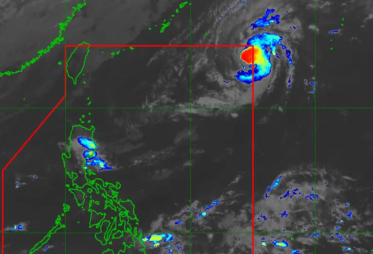
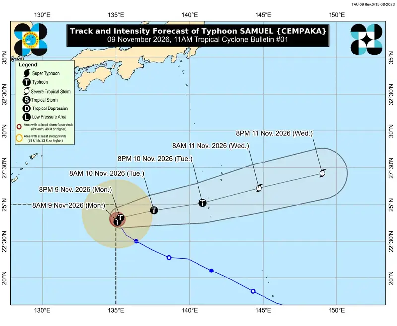
MANILA, Philippines – The typhoon with the international name Cempaka entered the Philippine Area of Responsibility (PAR) at 8:40 am on Monday, November 9, but it is not expected to have an impact on any part of the country.
Cempaka was given the local name Samuel, as the Philippines’ 19th tropical cyclone for 2026. It is also the first tropical cyclone for November.
As of 10 am on Monday, Samuel was located 1,370 kilometers east northeast of extreme Northern Luzon, moving north northwest at 20 kilometers per hour (km/h).
So far, the typhoon has maximum sustained winds of 120 km/h and gustiness of up to 150 km/h.
In its 11 am bulletin, the Philippine Atmospheric, Geophysical, and Astronomical Services Administration (PAGASA) said Samuel may strengthen in the coming hours, with its maximum sustained winds possibly reaching a peak of 150 km/h by Tuesday morning, November 10. But also on Tuesday, the typhoon is likely to start weakening.
Samuel will remain far from Philippine landmass and will not affect weather or sea conditions in the country. Its stay inside PAR will also be brief, as it is projected to exit by Monday evening or early Tuesday morning.
On Monday, the Philippines’ sources of rain include the northeast monsoon or amihan and the easterlies or warm winds from the Pacific Ocean.
The northeast monsoon may cause moderate to at times heavy rain in Cagayan, Isabela, Quirino, Apayao, Kalinga, Mountain Province, Ifugao, Aurora, and Quezon, as well as isolated light rain in the rest of Cagayan Valley, the rest of the Cordillera Administrative Region, the rest of Central Luzon, the rest of Calabarzon, Metro Manila, and the Ilocos Region.
PAGASA added that the northeast monsoon will bring strong to gale-force gusts to these areas:
Monday, November 9
- most of Luzon and Visayas, Dinagat Islands, Surigao del Norte, Misamis Oriental, Camiguin, Lanao del Norte, Misamis Occidental, Zamboanga del Norte, Davao Oriental, Davao Occidental, Sarangani
Tuesday, November 10, to Wednesday, November 11
- most of Luzon and Visayas, Dinagat Islands, Surigao del Norte, Misamis Oriental, Camiguin, Misamis Occidental, Zamboanga del Norte, Davao Oriental, Davao Occidental, Sarangani
The northeast monsoon is also causing dangerous conditions in various seaboards across the country on Monday.
Up to very rough seas (travel is risky for all vessels)
- Northern seaboard of Batanes – waves up to 5.5 meters high
- Northern seaboard of Babuyan Islands; remaining seaboard of Batanes – waves up to 5 meters high
- Northern seaboard of Ilocos Norte; northeastern seaboard of mainland Cagayan; remaining seaboard of Babuyan Islands – waves up to 4.5 meters high
Up to rough seas (small vessels should not venture out to sea)
- Seaboards of Isabela and northern Aurora; northern seaboard of mainland Cagayan; northern and eastern seaboards of Polillo Islands; remaining seaboard of Ilocos Norte – waves up to 4 meters high
- Seaboards of Ilocos Sur, Isabela, and northern Quezon; northwestern seaboard of Pangasinan; northern seaboards of Camarines Norte and Kalayaan Islands; remaining seaboard of Aurora – waves up to 3.5 meters high
- Seaboard of northern La Union; northern seaboard of Camarines Norte; northern and eastern seaboards of Catanduanes; northeastern seaboards of Northern Samar and Eastern Samar – waves up to 3 meters high
Up to moderate seas (small vessels should take precautionary measures or avoid sailing, if possible)
- Southern seaboard of Catanduanes; eastern seaboards of Albay and Sorsogon; northern seaboard of Northern Samar; eastern seaboards of Eastern Samar, Dinagat Islands, and Siargao-Bucas Grande Islands; remaining seaboards of La Union, Pangasinan, and Kalayaan Islands – waves up to 2.5 meters high
- Seaboards of Zambales, Lubang Islands, Palawan including Calamian, Cuyo, and Cagayancillo Islands, Caluya Islands, Zamboanga del Norte, and Surigao del Sur; eastern seaboard of Davao Oriental; southern seaboards of Oriental Mindoro and Occidental Mindoro; remaining northern and eastern seaboards of Quezon; remaining seaboards of Polillo Islands, Camarines Norte, and Catanduanes – waves up to 2 meters high
Meanwhile, the easterlies are bringing scattered rain and thunderstorms to Camarines Norte, Camarines Sur, Catanduanes, Albay, Sorsogon, Caraga, Davao Oriental, and Davao Occidental, and isolated rain showers or thunderstorms to the rest of Bicol, Mimaropa, the Visayas, and the rest of Mindanao.
While the country faces the effects of El Niño, the presence of the weather phenomenon in the tropical Pacific Ocean does not mean there will be no rainfall in the Philippines or zero tropical cyclones inside PAR.
El Niño only leads to reduced rain, and tropical cyclones can still enter PAR. Tropical cyclones could be fewer, but they may still reach typhoon or even super typhoon status during El Niño. – Rappler.com