



West. It is all you ever hear said of journeys in the United States. Route 66 trades on it. Every pioneer, settler and gap-toothed gold-panner was utterly obsessed with it. Throw in the Midwest, the Wild West, country and western music and the Gateway Arch in St Louis – often referred to as the “Gateway to the West” – and you might start to wonder whether the American compass is broken. Or if, at the very least, it has just one cardinal direction.
And yet, if you stand in the middle of Portland, the direction which calls most persuasively is east. True, Oregon’s biggest city – an unfailingly hip enclave of bars, book stores, food markets, coffee shops and 2.5 million souls – lies within day-trip range of the American Northwest’s fabled coastline. The call of that jagged shore, 70 miles to the west, can be strong. But equally, if you go east, you fall straight into the arms of a geographical icon whose magnificence rivals anything the Pacific oceanfront has to offer.
The Columbia River Gorge has quite the story. Archaeological evidence suggests the region has been inhabited for at least 13,000 years, the salmon in its shallows sustaining human life from the end of the last Ice Age onwards. And it was home to the Multnomah and other indigenous peoples long before the westward expansion of America brought it into modern view – although that first documented encounter with the gorge has a cherished place in the US timeline.
It was “discovered” by (Meriweather) Lewis and (William) Clark, the explorers whose near-three-year expedition from St Louis to (what is now) Oregon (and back) – seeking a land-route to the Pacific – marked the moment when America came to understand its own size and scale. They passed through the gorge between October 28 and November 3 1805 – and were enthralled by it.
“We proceeded along a river enclosed on each side by cliffs of 90ft; of loose, dark-coloured rocks,” Clark wrote. “We proceeded on, the mountains high on each side, containing scattering pine and white oak; the hillside steep and rocky.”
Little has changed. While the Columbia river is now an international waterway, taking its time – and 1,243 miles – to wind between the Canadian Rockies in British Columbia and the American Pacific in Clatsop County, the gorge is strictly starred-and-striped. It stretches for 80 miles, beginning at the confluence with the Deschutes river, and flowing west almost to Portland’s doorstep. In sections, it is 4,000ft (1,220m) deep.
As if to emphasise the extent of the groove it cuts into the American bedrock, the state line between Oregon and Washington runs along its middle for its entire length (and liking this arrangement, continues to trace the river right into the Pacific’s embrace).
It feels astonishing that a thing of such natural beauty can be found so close to a significant metropolis. But as is the American way, it is easy to slip between the former and the latter. Interstate 84 picks me up (almost) at the heart of Portland, flirts with a few flyovers, then drops me on to the riverbank 30 minutes and 20 miles later.
The contrast is sharp and sudden enough to give me whiplash. Vista House – up on the bluff of Crown Point – keeps the promise inherent in its name. A squat, circular structure – built as a roadside pit stop in 1918, just as the car was starting to draw American motorists to scenic places – it showcases a view of unmitigated splendour. Below, the Columbia is decadent in its width, beginning to broaden as it contemplates its estuary miles to the ocean. It becomes a narrower, more nuanced thing if you follow it upstream.
And the Interstate goes with it. I-84 is an impressive construction in its own right, linking Portland to Echo in north-west Utah via the Idaho capital Boise and 770 miles of tarmac. Yes, its multi-lane presence by the gorge is incongruous, a noisy man-made intrusion into a realm shaped by glacial precision. But the scenery does its best to overcome the traffic hum. And wins the battle, by resorting to one of the most glorious sounds available to any self-respecting mountain range: water splashing down from a considerable height.
Latourell Falls make this point gorgeously specific – as a single torrent plunging 249ft (76m) from an overhanging basalt cliff, the reward at the end of a mile-long trail. Siren-like, it draws me to the rocks at its feet, and with a slight change in the breeze, envelops me in a cloud of spray. No matter. It is a hot day. The light soaking is welcome.
Other such showers are available. If speed is not of the essence, and you do not wish to race to the end of the story, the Historic Columbia River Highway is a pleasingly slower-paced alternative to the Interstate. Like Vista House, it is a legacy of the first motoring boom – laid down between 1913 and 1922 as part of the burgeoning American belief that a road could go anywhere.
It remains steadfast in this purpose in 2026, connecting the key locations along the gorge’s southern flank. Latourell Falls is followed by Shepperd’s Dell Falls (suitably pastoral in the way its currents emerge from the treescape), Bridal Veil Falls (a roaring phenomenon, dropping 118ft/36m in two stages) and Wahkeena Falls (another 243ft/74m of downward motion, accessed via a short path).
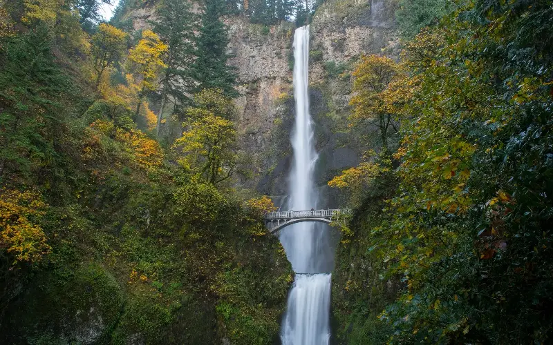
Then comes the superstar, Multnomah Falls – nominatively in sync with the gorge’s indigenous bloodline. Legend has it that Chief Multnomah’s daughter threw herself from the ridge above, answering the Great Spirit’s demand for a sacrifice that would save her tribe from a plague. Whether or not the cascade really burst forth in acknowledgement of her selfless actions, it is a mighty sight – at 620ft (189m), the tallest waterfall in Oregon. To walk across the bridge halfway up it is – again – to leave yourself open to a spritzing.
There are other such marvels on the road ahead – Ponytail Falls, Horsetail Falls, Elowah Falls and Wahclella Falls – and you might easily spend a week admiring this eternal dance of water and gravity. But when I reach the town of Hood River, 60 miles east of Portland, I choose to take a detour. This means a swerve into a separate river valley (of the same name), and on to a different highway (Oregon Route 35), but I am determined to take a proper look at the behemoth which Lewis and Clark – keeping to the Columbia on both the outbound and return legs of their odyssey – were unable to inspect at close quarters.
Not that you need to leave the gorge to see Mount Hood. A vast stratovolcano, rearing to 11,249ft (3,429m), it broods some 35 miles down the road. And it dissembles. Although it wears a cloak of snow, and has maintained a calm demeanour since its last outburst (in 1866), it is considered the Oregon volcano most likely to erupt within the next 30 years.
A safe enough window, I decide, to let me creep towards it, past the wineries flanking the tarmac in Pine Grove and Lenz, and stare upwards, hypnotised. And while my cardinal direction in doing so is neither west nor east, but south, the view is dazzling all the same.
Essentials
The Columbia River Gorge and the Hood River Valley both feature in the 15-day USA Pacific Northwest Self-Drive Tour sold by Audley Travel. From £4,520 per person, including international flights and car hire.
Further information visit traveloregon.com and travelportland.com.